Angela Pedroncelli is a Civil Engineer with almost five years of experience in land development. She brings project management and design experience to development projects from entitlement through construction document approval. Angela’s portfolio includes residential subdivisions, townhomes, and apartment complexes throughout Northern California. Her professional experience includes site, street, underground utility and grading design. Angela […]
Category: Uncategorized
DK ENGINEERING WELCOMES MICHAEL BALTAZAR, SURVEY TECHNICIAN!
Michael Baltazar recently graduated from the University of the Pacific with a Bachelor of Science in Engineering Management with an emphasis in Civil Engineering. His work experience to date has been centered in the Land Surveying field. In the public sector, he was involved with construction staking and traverse surveys of wastewater collection systems. Currently […]
dk Engineering at the Cal Poly San Luis Obispo Career Fair 1/17/2020
dk Engineering participated in the 30th Annual Civil & Environmental Engineering Career Fair at Cal Poly San Luis Obispo. Scott Hartstein and Cal Poly Alum Andrew Duarte (pictured at our table) attended the event on Friday, January 17, 2020. If you are interested in applying for a Civil Engineering or Land Surveying position, please email […]
Happy Holidays from dk Engineering!
We would like to extend a heartfelt thank you to our valued clients, friends and colleagues for your trust, your vision, and your partnership. The dk team wishes you every happiness this Holiday Season and prosperity in the New Year. The offices of dk Engineering will be closed for the Holidays: 12/25/2019 to 1/1/2020 […]
Aerial Drone Photography Maps Deliver for Developers
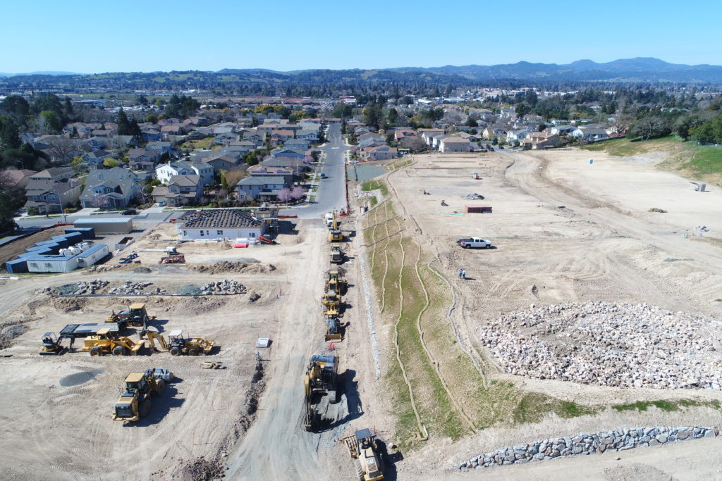
Aerial Drone Photography–an unmanned camera that can fly sky-high, is a break-through development in aerial photography in the 21st century so far. This technology makes taking aerial photos a lot easier. Drone photography is now used for commercial purposes, too, especially in the geospatial industry. The variety of sensors and cameras drones have to offer allows professionals to collect aerial data for mapping. […]
Volunteering at the Contra Costa Food Bank
Some of our dk Engineering team members volunteered at the Contra Costa Food Bank on Tuesday September 24, 2019. Our employees enjoyed giving back to our community by offering our time and energy. We are pleased to be able to help ensure that safe food is available to the hungry in our community. Our staff […]
dk Engineering will be at the ASCE UC Davis Career Fair on October 18, 2019!
We are excited to announce that dk Engineering will once again be a part of the ASCE UC Davis Civil Engineering Career Fair on October 18th! Please come by and visit our table. Event Details: Fifth Annual Civil Engineering Career Fair Friday, October 18th, 2019 9:00 AM – 12:00 PM ARC Ballroom A and B […]
Celebrating Employee Anniversaries and dk’s 40 years!
Celebrating lots of anniversaries with a Lobster Feast and summer bbq! Kevin’s 30 year, Matthew’s 20 year, and Scott’s 15 year employee anniversaries as well as the company’s 40th anniversary! […]
dk Engineering Celebrates Our 40th Anniversary!
There’s a big reason to celebrate today—it’s the official 40th anniversary of dk Engineering! What started as a small-sized engineering firm in 1979 has evolved into a top firm in the civil engineering, mapping, planning, and construction fields, and been named a “Great Place to Work” by Fortune. Andy Palffy, President of dk and partner in the […]
dk Engineering Welcomes Lillian Xie, Engineer!
Lillian Xie graduated from UC Davis with a bachelor’s degree in Civil and Environmental Engineering. She has been working in the land development industry for almost 3 years. The bulk of her experience is in residential subdivisions, with projects ranging from small developments to large master planned communities. Her skills include underground utility design, grading […]